
Earlier today the Arrive Alive website received the following request for assistance:
Question:
What are the blue sign plates on the e.g. N1,N2, N6 on the side of the road called & what is the meaning of these?
Answer:
We referred for an answer to an earlier post on the Car Insurance Blog titled Knowing these road markings can help save a life with increased response time to car accidents!
What road users need to know:
• The kilometre marker is not a legislated obligation but is a SANRAL standard on all national roads. [SANRAL is the South African National Roads Agency]
• A specific format is followed with regards to the actual markers (not size etc of signage).
• On the N4 Toll Route (Pretoria to Maputo) kilometre markers are placed at 200m intervals and the markers with the TRACassist number are placed at 2km intervals
• Standard kilometre marker boards are used along that section of the road.
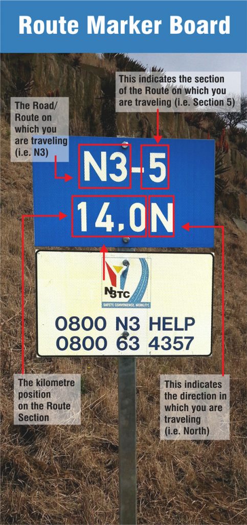
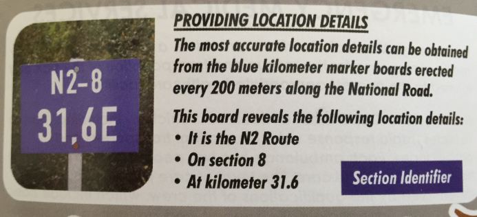
What does the info mean?
N4 = road/route on which you are travelling i.e. N4
8X = indicates the section of the N4 route on which you are travelling i.e. 8X
68,0 = indicates the kilometre position on the route section
E = indicates the direction in which you are travelling in i.e. EAST
TRACassist number = the emergency number to call for any type of emergency or roadside assistance on the N4 Toll Route (between Pretoria and Komatipoort)
These signs are of significant importance to road users. The road users should know that in case of emergency he would be able to pinpoint his location to emergency services by providing the detail on the marking closest to him. He should be able to find this information by merely moving 100 metres to his left or right.
Another Example from the N1:

The Sudden Unforeseen Stop and Roadside Emergencies https://t.co/CCwzWmln25 #ArriveAlive pic.twitter.com/cD8Ciydw3X
— Arrive Alive (@_ArriveAlive) April 19, 2017